Live: ABC meteorologist Nate Byrne answers your questions about El Niño
live
El Niño Q&A live: Experts answer your questions as BOM declares weather event

The Bureau of Meteorology has formally declared an El Niño weather event, meaning one is underway for the first time since 2023.
The major climate events impact the weather patterns of 60 per cent of the globe, and Australia is particularly vulnerable.
To help make sense of this, ABC News Breakfast meteorologist Nate Byrne and the Climate Council's Andrew Watkins will join us on the blog to answer some of your questions about El Niño.
Join us live.
Submit a comment or question
Live updates
New: Filters
Choose what information you see below by using filters
Thu 18 Jun 2026 at 12:25pm
How do strength and severity interact with one another?

G'day, is it true that the strength of the El Nino doesn't directly relate to the severity? So the fact that it will be the strongest on record doesn't necessarily mean it will be the most severe in terms of drought? Also — isn't the Negative IOD in some ways more important and if that keeps up then it will couneract the El Nino? I believe El Nino's and Negative IOD's are quite rare together?
— WeatherNuffy
Hi there WeatherNuffy,
Thanks for joining us on the blog.
Here's ABC News Breakfast meteorologist Nate Byrne with an answer:
Totally correct — strength doesn't correlate very well with intensity, but it does have an influence for us. One of the main concerns is if the strength allows it to carry on through summer (when El Niño typically breaks down) and last longer.
The Indian Ocean Dipole (kinda of like the El Niño Southern Oscillation, but to our west) and the Southern Annular Mode (another climate driver, but to the south) tend to have more of an influence during summer, but El Niño still factors in.
A negative IOD usually increases rain, and they rarely coincide because the two oceans are interconnected, but it has happened before.
Key Event
Thu 18 Jun 2026 at 12:15pm
Is climate change making El Niño more extreme?
I don't understand the relationship between El Niño and climate change? I know El Niño events are bad but aren't they cyclical?
— Carolina
Hi Carolina,
Here's an in-depth answer to your question from the Climate Council's Andrew Watkins:
Yes, El Niño are cyclical — they occur every 2-7 years. But it's their impacts that are being supercharged by climate change because of the extra heat put into the atmosphere and into the oceans. This is making the extremes associated with El Niño events more significant, as they (fires/drought/heat) have a greater risk of occurring in any year now due to climate change, and El Niño boosts that risk even higher.
Scientists are still working to fully understand the interaction between the pair. El Niño is a natural, periodic shift in Pacific Ocean temperatures that alters global weather patterns for several months.
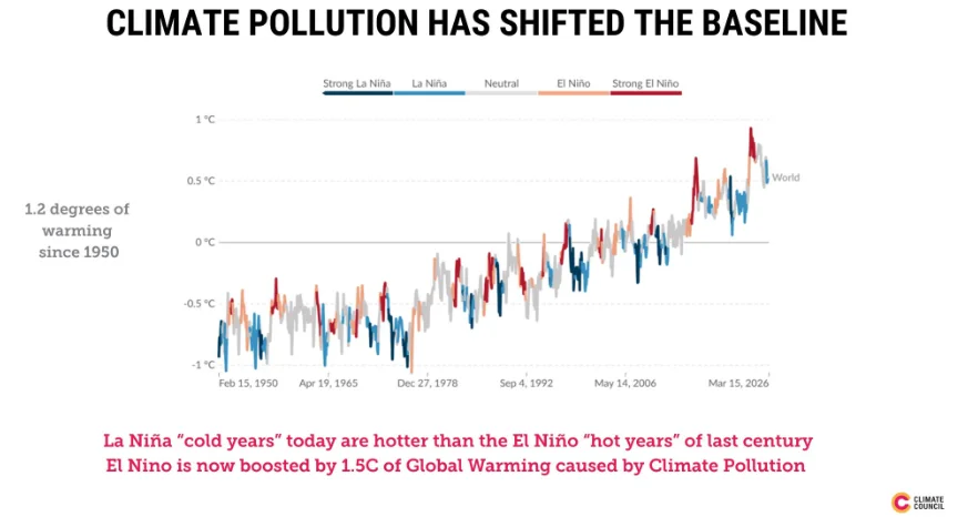
But in recent decades, we are seeing more of the stronger events, and more of the multi-year events as well.
One thing is certain — climate change will compound all of the impacts that El Niño brings. We are entering El Niño from a baseline that is 1.5°C hotter than pre-industrial levels thanks to our burning of coal, oil and gas.
So if El Niño brings heat, climate pollution will make it even hotter. And with every degree of global warming meaning the atmosphere can hold at least 7 per cent more moisture, there is a greater chance of extreme rainfall if we do occasionally get weather patterns that bring storms, or as the rains come back when the El Niño breaks down in autumn.
You can see from this graph how temperatures under both El Nino and La Nina have gotten warmer over recent decades.
Thu 18 Jun 2026 at 12:05pm
Will Perth be impacted?
Most of the predictions I see are for Eastern Australia, what can we expect in Perth? A hotter than normal and drier summer?
— Patrick
Lucky you, Patrick, both our experts have provided an answer!
Here's what ABC News Breakfast meteorologist Nate Byrne says:
That's because the impacts wane as you look further west, but for Southern WA it is certainly still slightly warmer and drier than average during El Niño years.
The bigger driver for the west is the Indian Ocean Dipole (IOD), but drier positive IOD years do tend to coincide with El Niño years more often than negative ones, which can make things much worse.
And here's Climate Council's Andrew Watkins:
With El Niño comes bigger high pressure systems over Australia, and in winter and spring that can mean more easterly winds for the southwest of WA. That means warmer days, warmer nights and less rainfall. SW WA has experienced around a 16 per cent decline in April to October rainfall since the 1970's, and El Niño can amplify this.
Key Event
Thu 18 Jun 2026 at 12:00pm
How can you prepare for El Niño?
Can I do anything to prepare my home/lifestyle to weather the impacts of El Nino? I live in regional NSW
— BC
Great question, BC!
ABC News Breakfast meteorologist Nate Byrne has given you a few helpful things to think about:
The best preparation you can do is to make sure that you get all those pre-summer jobs done before summer arrives:
- Clear fuel from around your home
- Start to think about managing water stores carefully on your property in the months ahead
- Clean those gutters before fire season
- Make sure you and your family have your emergency plans in place
We won't know about the summer bushfire outlook for a few months, but it never hurts to be ready, just in case.
Also, just because it's El Niño doesn't mean that everything is going to fall apart. Nevertheless, I think a lot of people underestimate the value of a little bit of peace of mind!
Thu 18 Jun 2026 at 11:55am
Will it makes our droughts worse?
Do we assume we're facing droughts over the next few years?
— Mohamed
Hi Mohamed,
Thanks for sending through your question! Here's Climate Council's Andrew Watkins with a response:
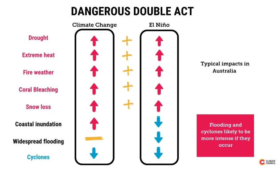
El Niño usually brings lower rainfall and higher temperatures/drier air to Australia, the key ingredients for drought. When you add in extra warming from climate change, we can expect the landscape to become dry due to low rainfall and higher evaporation, especially in spring going into summer.
This is very worrying for parts of Australia that have already had lower rainfall this year — including parts of NSW and Queensland, Tasmania, western Victoria and parts of WA.
I need to point out this doesn't mean no rain at all. In our warmer atmosphere, if rain does come, it's likely to arrive in short, intense bursts that can cause flash flooding rather than soaking into parched soil.
At the moment we can only look ahead for the current El Niño, which typically would peak in summer and end next autumn 2027, so we can't say for sure that dry conditions, if they emerge, would extend beyond that.
But if the soils get dry and rivers get low, we would actually need above average rainfall in 2027 to recover, so we always need to be cautious if drought emerges because they don't always disappear overnight.
Thu 18 Jun 2026 at 11:45am
When will El Niño end?
How long is it anticipated to last for?
— Kim
Hi Kim,
Lucky you, both our experts have provided an answer!
Here's what ABC News Breakfast meteorologist Nate Byrne says:
We can't be certain at this moment in time — a quirk of computer modelling is that inaccuracies grow faster the further into the future you look.
At this stage, it looks like it will last at least into 2027, but it could go significantly longer.
And here's Climate Council's Andrew Watkins:
Typically El Niño events peak in summer and end in the autumn, so we can expect this one to be locked in for several months now.
But their peak impacts are really in winter and spring. That said, climate change is boosting events these days and we are seeing more multi-year events than we did in the past. So in short, El Niño is here until at least early 2027, but we can't rule out further impacts well into next year.
Key Event
Thu 18 Jun 2026 at 11:35am
Will Australia still get cyclones?
Are we likely to see more TCs during summer with this climate swing?
— Nick
Hi Nick, looping in Climate Council's Andrew Watkins to answer this one for you:
Another great question.
We usually expect there to be fewer cyclones during an El Niño year as the waters to our north are not quite as warm as in La Nina years.
Climate change is also reducing the frequency of cyclones. However, if we do get any cyclones, they could be stronger. That's because a warmer atmosphere can carry more moisture, and it's the energy carried by the evaporation process that fuels our tropical cyclones.
Thu 18 Jun 2026 at 11:21am
When was the last El Niño event in Australia?
ABC News Breakfast meteorologist Nate Byrne is now taking us back in time to the last El Niño event we saw in Australia:
I reckon some people think back to the 2019/2020 Black Summer, but that wasn't an El Niño (it happened after an event in 2015-2016, followed by years of drought).
The latest El Niño was in 2023-2024. It started in mid-2023 and developed as a moderate to strong El Niño that set the record for Australia's driest 3 months (from August to October), but then it weakened and the summer brought the east a bunch of rain events, bringing devastating floods even as El Niño carried on.
It dissipated in April 2024. Because of the quick swing, we didn't see a lot of the long-term impacts of an El Niño, so many people in Australia didn't really even notice. That wasn't the case across the board, and certainly not the case overseas.
Key Event
Thu 18 Jun 2026 at 11:10am
Could we be in for a summer of severe heat?
Will it be much hotter this summer across the country?
— Richard S
Hi Richard, thanks for your question.
Here's what ABC News Breakfast meteorologist Nate Byrne has to say:
It's certainly possible, but that hasn't always happened in El Niño years beyond what we normally get.
The likelihood of heat in the south is increased, and we do tend to get more heatwaves. Interestingly, it's partly because we generally see fewer cyclones, which can knock a lot of heat out of the tropics (and often deliver much-needed summer rain).

That's not to say we won't see cyclones, though — Australia has never recorded a year without a cyclone crossing the coast.
The increased heat and heatwave risk can also worsen our bushfire outlook, but that also depends a lot on other factors including our cool season preparation and hazard reduction.
Key Event
Thu 18 Jun 2026 at 11:04am
How do the different states and territories experience El Niño?
How do the El Nino influences on Australia's weather and climate play out on the east coast v west coast?
— Clint
Morning Clint,
I've lined up ABC News Breakfast meteorologist Nate Byrne to take this question. Here's what he says:
It varies wildly across the country, and at different times (and depending on other climate drivers that happen to our west and south) because we are so vast and have such diverse weather patterns.
Eastern Australia tends to bear the brunt, with reduced winter rainfall, warmer temperatures and more frost. That extends through the south to Western Australia, but the effect is generally weaker the further west you go. Also, we generally get less snow over the Alps in the southeast (but that doesn't mean there won't be some good dumps!).
The warmer temperatures and lower rainfall persist into spring for eastern Australia as a whole, though the eastern seaboard gets fairly average falls, while WA tends to depend more on what's going on in the Indian Ocean. Then we start to feel it in the tropics, with the build-up holding on for longer in the Top End. The later onset of the wet season can choke off a supply of summer rain for the rest of the continent, but that all depends on exactly when and where tropical systems form, and how they move and develop (and they don't need to get to cyclone strength to still be a major event).
Otherwise, El Niño tends to make our summers swing more wildly — think an increased risk of bushfires and heatwaves — but more heat in the atmosphere can also lead to big rain events and flooding. We'll have a much better idea towards the end of spring.
If it carries on into autumn, we start swinging back to the things we feel in winter — reduced rainfall, warmer temperatures and more frost for the eastern and southern states.
Keep in mind that this is a global event — typically global temperatures rise following an El Niño event, and that can contribute to even more extreme weather events in the long term.
Key Event
Thu 18 Jun 2026 at 10:57am
What does this mean for snowfall this ski season?
Lots of similar questions coming through regarding the ski season!
Climate Council's Andrew Watkins has kindly given an update on what to expect:
Snow seasons in Australia are fickle at the best of times — and I should know as I am a skier myself (season pass for Hotham bought already!)
Snow seasons tend to be shorter and with less peak depth in El Nino years, as there is not as much moisture in the air. They also tend to finish earlier, as spring can bring rain not snow. BUT drier air and cold nights (from less cloud) can make for better snowmaking conditions.
Unfortunately climate change and El Nino combine to make snow seasons less reliable. I'll be chasing the snow when it falls.
Thu 18 Jun 2026 at 10:52am
Do we know the short-term and long-term impacts?
How is this going to affect our weather moving forward?
— Ashleigh
Day to day, we'll barely notice it.
El Niño is a nudge on the weather, but one that adds up over time. Temperatures will be slightly warmer over winter ON AVERAGE — we'll still get cold days and nights, but generally not quite as cold as they'd normally be.
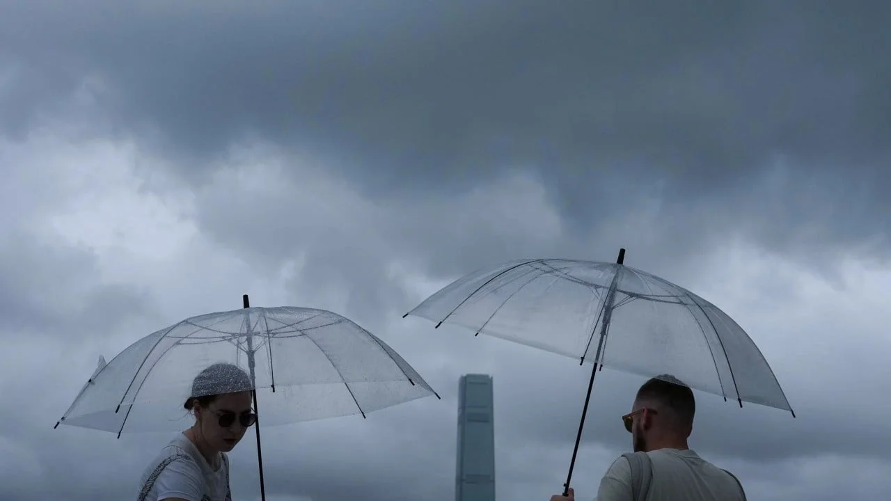
Similarly, there will be slightly less rain than normal ON AVERAGE — don't put away your umbrella or gumboots but maybe think twice before having that super-long shower. Also, it might not make sense at first blush, but the reduced rainfall usually means clearer skies which — despite the slightly elevated temperatures — can mean more frosty mornings.
Typically, El Niño lasts through winter and spring and starts to decay in summer, but they can last up to a year, and occasionally we can get subsequent back-to-back El Niño events for 2 years or more. That's where things get really dangerous for Australia — multiple winters of low rainfall and warmer temperatures can significantly elevate the summer bushfire and drought risk.
It can also reduce activity in the tropics later in the year (we typically end up with fewer cyclones than the average), and it can delay the onset of the northern wet season.
The tricky thing is that no two El Niño events are the same — the weather is still the unknown variable with this climate push, and it just takes one wayward cyclone, deep cold front, or east coast low to change our fortunes significantly. To complicate things even further, there are other climate drivers — the Indian Ocean Dipole (IOD) and the Southern Annular Mode (SAM) that can sway the pendulum and either reinforce or combat El Niño.
Finally, how we prepare and how we behave can change things too — good fuel reduction and land management policies, water conservation and disaster preparedness can take the sting out of the tail, buy us time, or at least help us recover more quickly when things get tough.
Key Event
Thu 18 Jun 2026 at 10:46am
El Niño can help create the conditions for bushfire weather. Should we be worried?
How will this affect the bushfire season in Victoria?
— Connor
Will the El Niño result in bushfires as bad as the Black Saturday Bushfires?
— James
Hi Connor and James,
It looks like you're both on the same page when it comes to bushfires.
I've got Climate Council's Andrew Watkins here to answer that one:
Southern Australia is one of the most fire prone places on the planet. But unfortunately we need to be even more vigilant in our bushfire season because climate change has lengthened these fire seasons and made it possible for dangerous fires to burn at any time.
We don't need El Niño to have bad bushfires, for example 2019 when the Black Summer fires started was not an El Niño year. This past summer when fires destroyed more than 400 houses in Victoria, we were actually under a La Nina event which is supposed to bring cooler and wetter conditions.
But El Nino does typically provide a warmer and drier spring in the lead into the summer, which can often mean a greater fire risk, especially in Queensland and NSW, and can raise the risk of severe fire weather over the summer.
Fires can be difficult to predict but we should get a better look at the coming fire seasons at the end of winter.
Thu 18 Jun 2026 at 10:41am
📹 What is a super El Niño?
Prefer to watch a video on what an El Niño event is?
Check out this handy 3 minute video explainer:
Loading...Thu 18 Jun 2026 at 10:38am
What causes an El Niño event?
Let's try to answer this as simply as we can.
El Niño refers to an extended period of warmer-than-normal waters in the central and eastern tropical Pacific Ocean, which causes a shift in atmospheric circulation.
Typically, the equatorial trade winds blow from east to west across the Pacific Ocean. El Niño events are associated with a weakening, or even reversal, of the prevailing trade winds.
Warming of ocean temperatures in the central and eastern Pacific causes this area to become more favourable for tropical rainfall and cloud development.
As a result, the heavy rainfall that usually occurs to the north of Australia moves to the central and eastern parts of the Pacific basin.
Thu 18 Jun 2026 at 10:34am
Submit your questions for our Q&A
Our experts are ready to answer your burning El Niño questions, so that means it's time to send them through!
You can submit your questions to the blog by tapping the yellow "Login to comment" button above.
We'll try to get through as many as we can.
Thu 18 Jun 2026 at 10:30am
What did BOM announce?
It's official: El Niño has arrived.
On Tuesday, the BOM declared that the major climate driver was locked in across the tropical Pacific, with experts warning it could intensify into one of the strongest events in decades.
The Bureau has pointed out that "around half of the models indicate this event could peak at levels among the highest observed since 1950".
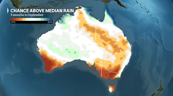
El Niño often brings drier conditions to central and eastern Australia in winter and spring. But Australia's weather is also shaped by other climate factors, so outcomes can vary.
Thu 18 Jun 2026 at 10:25am
Welcome to today's Q&A
Good morning and thanks for being here with us.
The Bureau of Meteorology (BOM) has officially declared an El Niño weather event, and there's a lot to unpack about what that means for us here in Australia.
To help break it all down, we've brought in a powerhouse panel:
- ABC News Breakfast meteorologist Nate Byrne, and
- Climate Council's Andrew Watkins.
So, if you've got any questions jumping out at you, now is the time to send them through.
Let's get straight into it!